Please click on the mountain images at the top or bottom of the page to navigate this site. Sorry for this temporary inconvenience.

Mount Sopris from Prince Creek Road.
Just south of the town of Carbondale, Colorado where the Crystal River meets the Roaring Fork River sits one of the most impressive mountains in the state. Although Mount Sopris doesn't even top out at 13,000 feet, its mile of vertical exposure creates an impressive backdrop for the town of Carbondale.
Note: That's Mount Sopris you see at the top of every page of this web site!
From the intersection of Colorado State Highway 82 and Highway 133, head south on Highway 133, through the town of Carbondale and at about 2.5 miles from the intersection (mentioned above) you need to turn left (east) on Prince Creek Road. Follow this road for about 5 miles or so (it turns to dirt at about mile 1.5) until you come to a potentially confusing intersection. Keep right to follow the road to Dinkle Lake. The parking area for the trailhead for Mount Sopris is at Dinkle Lake - about a mile and a half from the confusing intersection.
.")
View from within the Aspen trees (Quakies).
As this is a long day hike (rated moderate by the guide books) it is a good idea to begin your journey from Dinkle Lake early in the morning to beat the afternoon thunderstorms. The trail begins by slowly climbing through open range (be sure to close the gate or the cattle will get out) and stands of Quakies while following an old four-wheel drive road. Enjoy this section of the hike because its going to get a lot steeper!
After about 2 miles of hiking you will find yourself at Thomas Lakes. In this area you will notice several of the Thomas Lakes as the trail winds its way towards the base of the shoulder of the mountain. Just past the last lake the trail becomes steep with switch-backs (the switchbacks were constructed around 1992) which allow you to access the ridge you will follow west to the summit.

View of the summit from half-way up.
Once on the ridge you will notice the vegetation thinning as you climb and traverse further to the southeast. Once the trail reaches the edge of the neighboring valley you are pretty much at treeline. After the last tree (you will know which one I am writing about) the ridge becomes narrow however the exposure will most likely bother only persons with severe to extreme problems with heights.

Rain over the town of Basalt as seen from treeline.
In this area the trail is marked primarily by cairns as you will walking mostly on rock above tree line. At about 11,800 feet there is one section of trail that is really more of a scramble than a hike as the terrain becomes steep and rocky. You may end up using your hands for assistance as some of the rock in this area is loose and footing can be tentative.
From the lake below, you may have noticed that Sopris contains a false summit that you must cross before making your final pitch towards the real summit. Psyche!!! You still have several hundred feet of elevation to gain to reach the actual summit.

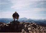
Hikers on the summit of Mount Sopris with the memorial visible at center-left.
For the last couple of hundred feet the trail continues its climb along the ridge overlooking Thomas Lakes. Near the top you kind-of go around back as you see the highest point. Psyche!!! This is the real false summit!!! Turn to your left (west) and you will see that the real summit is still several hundred feet away (but only about 30 feet higher than your current position). Just before the top you will notice a huge cairn which is really a memorial to a woman climber that lost her life on the mountain sometime in the mid - 1990's.
| |
 |
Crouching on the summit of Mount Sopris with Capital Peak on the horizon.
|
From the summit, the views are beautiful. Directly north you see the down-valley end of the Roaring Fork Valley with the town of Glenwood Springs lying at the base of the Flat Tops (and Flat Tops Wilderness) and Carbondale is right below you. On a clear day the mountains in the Routt National Forest are just barely visible on the northern (or north-northeast) horizon.

Looking up at the summit of Mount Sopris from the steep / loose section.
To the West is Chair Mountain, McClure Pass and Huntsman's Ridge. Southwest is probably the best view from this summit. It includes the West Elk Range and the continuation of the Elk Range to the south (including Capitol Peak). Beyond that to the southeast lay the ski areas of Snowmass, Aspen Highlands and Aspen Mountain. Directly east you will see the Sawatch Range and Red Table Mountain (in my opinion the best four wheeling for views around) to the northeast.

Snow and clouds in the saddle between East and West Sopris.
Note: Mount Sopris actually consists of two peaks (East and West Sopris) of the same elevation separated by a saddle about one-half mile in length. The second peak is about a half hour away and contains very similar views. You will have to retrace your steps to return as there is no trail down from West Sopris.

Coming down the steep / loose section.
On this mountain, the trip back down will take you as long as it took you to on the trip up! This is due to the fact that the entire trail is very rocky and virtually every step must be planned. If there is any climb that is as hard going down as it is going up, this is it!
 and Tommy (right) on top of Mount Sopris.")
Bernie (left) and Tommy (right) on top of Mount Sopris.
As you may have read above, this is a trip that I have taken every summer since moving to Colorado and it has become something of a ritual for me. I have been on the summit of East Sopris 10 times and West Sopris once. My time to reach the summit (East Sopris) has improved from over 5 hours my first time up to just under 3 hours - a milestone I broke this summer! |
Along on this hike with me: As I have undertaken this hike ten times so far it would be difficult for me to list all who have joined me on the summit. A partial list includes: John, Kevin, Walter, Sandy, Tommy, and Bernie. I have also completed this hike several times alone..

