
Trailhead
Trip Reports
Photo Essays
Map of Hikes
Hike Calculator
List of Links
Why I Hike
Echo
Mountain Towns
Warning
Misc. Photos
Photo Credits
F A Q
Trip Reports
Photo Essays
Map of Hikes
Hike Calculator
List of Links
Why I Hike
Echo
Mountain Towns
Warning
Misc. Photos
Photo Credits
F A Q
Please click on the mountain images at the top or bottom of the page to navigate this site. Sorry for this temporary inconvenience.
Starting Elevation:
10,2XX feet
Highest Elevation:
13,574 feet
Distance (round trip):
~ 8 miles
click on each photo to view a larger image
 |
|
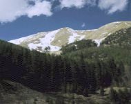
| The summit of Mount Parnassus from near the begining of the hike. |
We chose our route as we went and discovered a few small patches of snow that we had to cross which were tucked between some of the last trees below timberline. After slogging our way uphill through the snow and trees for several hundred yards we finally came out into the open. We were higher on the hill and found that we were now in a dead forest which somehow had an eerie beauty to it. Some of the trees were still standing and some were lying rotting, They had all been dead for many years so they were colored in shades of grew, gold and brown. At the top of the dead forest there was a relatively flat spot which we chose for a short break.
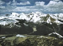
 My route up the ridge to the summit of Mount Parnassus as seen from Kelso Mountain.
 With my hiking partner in a safe spot, I continued up this steep slope through terrain ranging from loose dirt to a talus slope to grassy pitches. This went on for what seemed like forever - climbing about 50 ft. vertical - stopping for a moment to take a few breaths - and climbing again. In all actuality I probably climbed around 750 feet to reach the ridge which I would follow to the summit.
 to the summit of Mount Parnassus as seen from Bard Peak.") The ridge (left center) to the summit of Mount Parnassus as seen from Bard Peak.
The ridge (left center) to the summit of Mount Parnassus as seen from Bard Peak. After about 10-15 minutes of hiking along this ridge and with several other high spots out of the way, I reached the summit of what I was to discover is Mount Parnassus - 13,574 feet above sea level. The views from the top were outstanding! The sky was a wonderful Colorado blue, the clouds were puffy, white, and intermittent, and other than at a ski area I don't think I have ever been on top of a mountain when all of the other mountains surrounding me still had so much snow!
 |
|
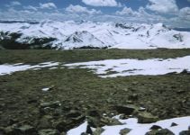
| Looking west down towards Eisenhower tunnel. |
After signing the register it was now time to head back down to try and find my partner. I made good time along the ridge but once I had to drop off the back side to retrace my steps, my progress became much slower. Going up my footing seemed pretty good however going down required careful thought about every foot placement. Some of the rocks were unstable which could have easily lead to a twisted ankle. Coming down this slope made me realize just how far I had climbed to get to the ridge!
 |
|
| The summit was large and relatively flat. |
After "picking up shop" we retraced our steps down the hill to a point higher up on Watrous Creek than where we had crossed earlier. This allowed us to use several snow-bridges to get to the other side of the valley. From there we followed the creek while traversing the hillside. This lead us to footprints in the snow which lead to the trail which took us back to the trailhead. Whew! Not bad for an early season hike!
Along on this hike with me: Larry.
