Trailhead
Trip Reports
Photo Essays
Map of Hikes
Hike Calculator
List of Links
Why I Hike
Echo
Mountain Towns
Warning
Misc. Photos
Photo Credits
F A Q


Please click on the mountain images at the top or bottom of the page to navigate this site. Sorry for this temporary inconvenience.

Mount Massive

August 28, 1999
San Isabel National Forest
Mount Massive Wilderness
Starting Elevation:
10,080 feet
Highest Elevation:
14,421 feet
Distance (round trip):
14 miles
click on each photo to view a larger image
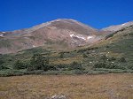
Towering just west of Leadville, are the two tallest mountains in the state - Mount Massive claims the title for being the second tallest at 14,421 feet while just south lay Mount Elbert, slightly taller at 14,433 feet.

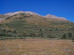
To get there, head south from downtown Leadville about 4 miles. On your right you will see Hwy. 300 and possibly a sign for Halfmoon Campground. Take Hwy. 300 eight-tenths of a mile then turn left on FR 110. This road will take you the additional six-and-a-half miles back and up in the valley between the aforementioned mountains. You'll pass the Halfmoon campground at about mile five, however the trailhead to Massive is a little bit further down the road.
The hike up Mount Massive begins with a 3-1/2 mile trek north on the Colorado Trail.
These three photos make up the approach to Mount Massive about 3-3/4 miles into the hike.  The highest of Massive's many summits is visible (center-left) in the photo on the right.
These three photos make up the approach to Mount Massive about 3-3/4 miles into the hike. The highest of Massive's many summits is visible (center-left) in the photo on the right.
Upon arrival, there were several people on the summit.  Although it wasn't planned, the hike turned into a loop hike rather than an out-and-back.  For weather reasons, the path followed the gentleman in the background (black dot, left center) down a couloir on back side of the mountain so as to quickly lose elevation.
Upon arrival, there were several people on the summit. Although it wasn't planned, the hike turned into a loop hike rather than an out-and-back. For weather reasons, the path followed the gentleman in the background (black dot, left center) down a couloir on back side of the mountain so as to quickly lose elevation.
Looking west-southwest down on North Halfmoon Lakes from the summit of Mount Massive.
Also from the summit, the view northwest on the back side of the mountain looks impressive, but ...
... it's time to go.  Look at those clouds rolling in over the summit in this photo taken to the southeast.  If you look closely, you can see Mt. Elbert Forebay (the smaller lake), and the eastern most of the two Twin Lakes.
... it's time to go. Look at those clouds rolling in over the summit in this photo taken to the southeast. If you look closely, you can see Mt. Elbert Forebay (the smaller lake), and the eastern most of the two Twin Lakes.
About half way down the couloir, I took a break to remove the gravel from my hiking boots.  That's when I took this photo looking back up to where I had just come down.
About half way down the couloir, I took a break to remove the gravel from my hiking boots. That's when I took this photo looking back up to where I had just come down.
Then I took a photo looking down on where I was headed - North Halfmoon Lakes.
The clouds were rolling in pretty thick by the time I reached the northernmost of the two lakes.  A light rain began to fall, however this storm lacked thunder or lightning.  Whew!
The clouds were rolling in pretty thick by the time I reached the northernmost of the two lakes. A light rain began to fall, however this storm lacked thunder or lightning. Whew!
After the rain and lower down the Halfmoon Creek trail, this photo was taken looking back up on the southwest shoulder of Massive.
A view of Halfmoon Creek valley looking east about 9-1/2 miles into the hike.
Looking northeast up the flank of Massive.
Looking west you can see Deer Mountain (13,761 feet) on the right and Mount Champion (13,646 feet) on the left.
Further to the east-southeast you can finally see Mount Elbert.
About Twelve miles into the hike the sky began to clear in this view of French Peak (13,940 feet) facing southwest.
Looking up the south side of Massive.
The end of the day, looking west back upon Mount Massive from along the road home - FR 110.
Along on this hike with me: no one.