Please click on the mountain images at the top or bottom of the page to navigate this site. Sorry for this temporary inconvenience.
This hike begins at Little Molas Lake on top of Molas Pass deep in the rugged San Juan mountains of southwestern Colorado. To get to Little Molas Lake, head south of Silverton, Colorado on US Hwy. 550 about 7 or 8 miles. Be sure that you go to Little Molas Lake on the west side of the highway and not Molas Lake about a half mile north on the east side of the highway.
From our camp site at Little Molas Lake, the sunset over Snowden Peak (13,077 feet) the night before our hike.
From left to right, Kendall Mountain? (13,066 feet) and Whitehead Peak? ( 13,259 feet ) also at sunset the night before our hike.
On the day of our hike, from left to right, West Turkshead Peak (12,849 feet), Turkshead Peak (12,734 feet), and Grand Turk (13,160 feet). This photo taken from the overlook on Hwy. 550.
Terese passing through one of the lower mountain meadows. If you look closely at the larger click-through image you can see a flock of domestic sheep behind her in the meadow on the right.
The way up to the Grand Turk (not visible) heads up through this valley and between the notch at the far end.
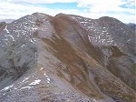
A closer view of the valley we had to climb up and over.
Once through the notch at the head of the valley, the terrain wasn't quite as intimidating and the view looking back on our path was stunning!
From slightly further along, here is the view back towards where we had just come.
From almost the same elevation, the view looking back on Turkshead Peak (12,734 feet).
Here's an even more dramatic view of Turkshead Peak.
Is that the summit of the Grand Turk? No - that's just another sub-peak along the way.
Terese coming over the top of the summit of the no named (?) sub-peak. The snow was new the day before our hike.
That's Sultan Mountain (13,368 feet) on the left and Grand Turk (13,160 feet) on the right. We crossed the saddle shown in this photo to get to the summit.
From the summit of Grand Turk, we were able to see the town of Silverton below us (to the northeast).
Just to the north is a view of the south face of Sultan Mountain.
To the south-southeast was a great view of Molas Lake (not little Molas Lake) and the Needle Mountains.
This is a view of the no named sub-peak which we had just come over (looking southwest).
Coming back down the mountain headed towards Little Molas lake, the sheep were now hanging out near the shepherd's camp site.
A slightly different view of the shepherd's camp site.
Along on this hike with me: Terese.

 the night before our hike.")
 and Whitehead Peak? ( 13,259 feet ) also at sunset the night before our hike.")
, Turkshead Peak (12,734 feet), and Grand Turk (13,160 feet). This photo taken from the overlook on Hwy. 550.")

 heads up through this valley and between the notch at the far end.")


.")


 sub-peak. The snow was new the day before our hike.")
 on the left and Grand Turk (13,160 feet) on the right. We crossed the saddle shown in this photo to get to the summit.")
.")

 and the Needle Mountains.")
.")


