Please click on the mountain images at the top or bottom of the page to navigate this site. Sorry for this temporary inconvenience.
Northwest of the town of Alma, Colorado lie three Fourteeners that can be fairly easily climbed by a moderately strong party in one day. Alma can be found about 12 miles South of Breckenridge or 6 miles north of Fairplay on Highway 9 near the north-westernmost corner of Pike National Forest. In downtown Alma, look for the sign to Kite Lake. This is the road that you will follow for about six miles past numerous remnants of Colorado's mining heritage. Overall the road to Kite Lake is fairly easily traveled by most passenger cars however you should beware of several creek crossings which may need to be scouted before passing.
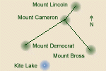
Relative position of the peaks and the lake.
Knowing that there would be lots of people in the area on a Saturday, we parked about a mile downhill from the lake on the side of an old mining road. This added about a mile each way to our hike that can be eliminated by driving all of the way to the Kite Lake camping area (fee area). Walking up the road to kite lake was easy as we scouted the large mountain looming above us wondering exactly which peak it was. Upon reaching the lake we were glad we parked where we did as cars were improvising with their parking arrangements due to crowds. Rock-hopping across the outlet of the lake we discovered exactly how crowded this area really was. There were probably around 30 or more tents set up in the camping area near the lake. I wondered why any one would want to camp in such a crowded environment with no trees, brush or even large rocks to add privacy to the campsite. To each his own.

The view downvalley from the summit of Mount Democrat.
There were several trails leaving the campsite however we decided to follow the obviously most heavily traveled road which led up into the basin above the lake. This road provided us with a gradual climb which somehow allowed us to gain quite a bit of elevation without noticing the fact that we were climbing. Nearing the foot of the actual mountains, the road becomes a trail as it turns left-ish (northwest?) and begins its ascent via numerous switch backs up the northeast face of Mount Democrat. The crowds on Democrat reminded me of my journey up Grays and Torreys Peak and I was beginning to dread what lay ahead of me. Later on I would discover that most of these people would be only bagging Democrat leaving Mount Lincoln and Mount Bross to only a select few (either that or due to our late start we were so far behind the hard core peak-baggers that we missed the crowds).

Looking at the summit of Mount Democrat from the false summit.
After passing several groups of hikers on the face of Democrat we soon realized that we were already higher than the saddle between Democrat and Mount Cameron (a Fourteener and a midpoint on the way to Mount Lincoln - but not counted as a real peak as there is not enough vertical difference between Cameron and Lincoln to qualify). In some places the trail up Democrat was quite worn and footing was tenuous at best however hiking with poles most definitely aided in my traction. After some scrambling to pass a large group of hikers resting on the trail I found myself at the false summit of Democrat.
The false summit provided me with a good view of the actual summit several hundred yards further and a maybe a couple of hundred feet higher than our current position.

Fremont Pass from the summit of Mount Democrat.
 and Mount Lincoln (left center).")
Mount Cameron (right canter) and Mount Lincoln (left center).
Several minutes later we sharing the summit of Mount Democrat (14,148 feet) with about 10 other people - most of whom appeared to be having a very good time. We even sang happy birthday to one woman as she reached the summit (her earlier-arriving friends clued us in on the occasion)! From the summit I discovered that I could see the tailings pond for the Climax Mine near the top of Fremont Pass. Now I know where I am! Not wanting to stay long on the summit due to potential weather issues and a long day ahead of us we headed back down the way we came until we reached the saddle between Democrat and Cameron - a loss of about 750 vertical feet. We took a short break in the saddle to hydrate and eat a little in preparation for the next climb.

The trail near the top of Mount Cameron.
The climb to the top of Mount Cameron follows a long ridge all of the way to the top - about a thousand feet. The trail in this area has less loose rock on it than the one that climbs Democrat. In the saddle a chilling wind was blowing but as the trail was just downwind of the actual ridge we debated whether or not to put on a jacket. We decided not to and pressed on comfortably. Nearing the top of Cameron the trail crosses over to the northwest side of the ridge. This adds some exposure to the hike but footing was good and there was really no fear of slipping off the side of the mountain.
The top of Mount Cameron (14,239 feet) is large and flat. We had a hard time finding the actual highest spot on this mountain but when we thought we had, we stopped for another break and finally added that jacket to keep the wind from chilling us further. About a half mile to the northeast of Cameron lay Mount Lincoln - a mere 47 feet higher than Cameron!

Mount Lincoln from near the top of Mount Cameron.
The walk over to Mount Lincoln (14,286 feet) was pretty easy as we had pretty much become acclimated to the altitude. The final pitch included a quasi-false summit and a slight scramble up through some rocks. Almost unbelievably we had the summit to ourselves for about 15 minutes before anyone else arrived. First to show up was Claire - a woman running these peaks! Claire is a former exile from St. Louis - as am I. Small world! Next to arrive was the fun-loving group we had met earlier on Democrat (not the birthday people). They included Lynn, Tom, Michelle (with two l's), and Dan. They were teachers at Pine Lane Intermediate School in Parker, Colorado out for an off-site event and they were having some fun! They shared some of their food with us including cold, fresh, green peppers and some of the best trail mix I have ever had. Last to arrive was Anh - a Denver native - now a graduate student at Washington University in St. Louis. More of that small world thing - the St. Louis connection!

Mount Cameron from the summit of Mount Lincoln.
From the summit we could see that there was weather happening to our northwest but would it head our way? Time will tell. After about a half hour on the summit we headed out once again working our way back towards Cameron which was essentially in the middle of these three peaks. This time the trail didn't take us quite back to the top of Cameron but around it's northeast side. The trail leads to several old mining roads which traversed back and forth across the north side of Mount Bross. Hiking these roads was pretty easy however there were quite a few of them and finding the right one seemed a little confusing at times.
 and Mount Lincoln (right) from near the summit of Mount Bross.")
Mount Cameron (left) and Mount Lincoln (right) from near the summit of Mount Bross.
With the occasional straight shot up and several switch backs across we were soon on top of Mount Bross (14,172 feet). The summit of Bross is huge and we settled in to one of several stone shelters (really only a rock wall about 4 feet high built on three sides to protect climbers from the prevailing winds) to hang out for a while. It appeared as though the weather would hold off for a while. Once again, we were the only ones there for about 15 minutes. First to arrive was Dan and Michelle (whom we were meeting for the third time). They asked about Lynn and Tom and we said that we hadn't seen them.
 and the shoulder of Mount Cameron (right) as seen from the summit of Mount Bross.")
Mount Democrat (left center) and the shoulder of Mount Cameron (right) as seen from the summit of Mount Bross.
Supposedly they were ahead of Dan and Michelle but they never did arrive. Once Anh arrived, he told us that he thought he saw them heading back down the mountain. Anh had reached the summit of Bross before we had however he wasn't sure of the way down so he returned to the summit and hung out on top with all of us for about a half hour. Dan took a nap while the rest of us enjoyed the beautiful, windless, late afternoon on top of the mountain.

Anh coming down from Mount Bross with Bernie following. Dan and Michelle are the two specs in the gully.
Needing to get down so we could get back to Denver we left the summit and scouted for a trail to take us back to Kite Lake. After heading out onto a ridge to the southwest of the summit, we decided we saw a trail in the gully below us to the east. We scrambled over mostly small loose rock to reach this trail which really wasn't much better than the scramble. We stopped at least twice to remove gravel from our shoes and once while doing this I dropped my shoe and watched it slide to a stop about 20 feet below me. :-)
After gathering my shoe and climbing back up to the trail we were once again on our way down.

Mount Bross from just above Kite Lake.

Kite Lake. Can you figure out how it got its name?
Our total elevation loss in this gully was about 2000 feet however about 500 feet above the lake the terrain turned to grassy meadow at the foot of the actual mountain. Coming out of the gully was a small stream fed by the remains of last season's snow and this stream upon reaching the meadow provided us with a small waterfall with which to rinse off some of the day's dirt from my hands, face, and legs. About a quarter of a mile below the waterfall we once again reached the campground at Kite Lake.

From the summit of Mount Bross one can barely make out Pikes Peak on the horizon.
Although this hike started out to be exceptionally crowded it turned out that the people we met along the way were quite fun and had a genuine appreciation for climbing and the mountains. They weren't like the tourons you find on Grays and Torreys Peaks and I enjoyed their company on this day when I bagged three Fourteeners at once! |
Along on this hike with me: Bernie.

